Sir Humphrey’s Role in Somerset Fracking Obfuscation

It has recently been reported in the local press that the Chew Valley, Bath and Mendip will remain free from fracking for Shale Gas. This is based on an announcement by Ben Howlett MP (Bath) following a meeting that he and James Heappey MP (Wells) had with the responsible Secretary of State the Rt Hon Andrea Leadsom. Ms Leadsom wrote to Mr Howlett saying that “Bath and the surrounding areas are not located in the British Geological Survey’s ‘shale prospective area’.

NB – Mr Jacob Rees-Mogg doesn’t seem to have been invited to Ms Leadsom’s tearoom surgery.

Ms Leadsom’s letter to Mr Howlett is reproduced on his web site and is reproduced below in blue italic.

Mr Howlett commented “As the Minister, Andrea Leadsom, said in her response to me I regret that this situation has been unclear both to me and my constituents and am relieved and reassured by her response“.

However, Ms Leadsom seems to have persuaded Sir Humphrey Appleby GCBKBEMVOMA (Oxon), (a “master of obfuscation”) to draft the letter for her as it is simultaneously both truthful and utterly disingenuous. Let’s see what Sir Humphrey had to say and whether what was unclear is now clear and whether we can also feel “relieved and reassured”.

Sir HumphThank you for attending my tearoom surgery recently. I hope you found our discussion about the shale reserves in Bath and the Mendip Hills helpful and thank you for raising this matter with me.

Not a good start. Why was the conversation about ‘shale reserves’ rather than the ‘coalbed methane resources’ that the gas companies have been searching for in this area for the past 20+ years?

These companies (include Pendle Petroleum in 1985, Union Texas Petroleum Inc in 1995, GeoMet Inc in 2000 and UK Methane in 2014) were all looking for CBM according to the licence applications and relinquishment reports filed in Sir Humph’s filing cabinet.  Considering that these companies all delivered their reports to Sir Humph’s Department saying they were looking for CBM it is odd he didn’t bother have a peek to find out and so save embarresment.

Also Shale Gas ‘reserves’ (what can be technical and economically extracted) certainly don’t exist because the economic value of any Shale Gas in the area have certainly not be calculated. The dextrous use of the word ‘reserve’ rather than ‘resource’ is a careful double blind to hide behind. So they were discussing something that hasn’t been calculated (reserves) for something that isn’t of primary interest in the area (Shale Gas).  Of course Sir Humph knows all about this because his Department has published a note on this very point in order to prevent, rather than create, confusion – Resources vs Reserves: What do estimates of shale gas mean?

And what about the tearoom cake reserves?

Sir HumphBath and the surrounding areas are not located in a ‘shale prospective area’ according to shale resource estimates by the British Geological Survey.

So what? The companies are not primarily looking for Shale Gas. Opps – there is the word ‘resource’ instead of ‘reserve’. This is because BGS has got a map of Shale Gas resources but it hasn’t got a map of Shale Gas reserves – because it hasn’t calculated any.

In addition, Bath (as a World Heritage sire) and the Mendip Hills (as an Area of Outstanding Natural Beauty) are afforded the highest level of protection within our planning system.

The highest level of protection is afforded to hydraulic fracturing for Shale Gas at the exclusion of CBM.  The definition of “associated hydraulic fracturing” and related protection in the Infrastructure Act 2015 is specific to shale and stuff “encased in shale”, which does not include coal – as confirmed in writing to us by Sir Hump’s very own Department.

Sir HumphIn addition, there are currently no active Petroleum Exploration and Development Licenses (PEDLs) in the Bath area. In 2008 the Government issues PEDLs in Bath and North East Somerset, as part of the 13th round licences. In July 2014, three of the PEDL licences in this area were relinquished by the licence holders and another licence was extended for further year until July 2015 but has since been relinquished.

PEDL 227 covering the most prospective area for CBM was not available in the 14th Licensing Round because the previous licence hadn’t been relinquished in time. There is nothing stopping the Bath and Mendip area being licensed again in the 15th Licensing Round if anyone were interested – as it has been in the past. Sir Humph obviously hasn’t looked at the 2008 PEDL licence applications or the relinquishment reports otherwise he probably wouldn’t have even drawn attention to them considering what they contain – a plan to comprehensively extract the entire hydrocarbon resource in the area using a combination of fracking, mining and underground coal gasification.

Sir Humph:  “Even if there were shale gas reserves, the recent announcements on fracking would make obtaining permissions for drilling at the surface extremely unlikely.

Note the use of the word ‘reserves’ again – there aren’t any Shale Gas ‘reserves’ because they haven’t been calculated and nor have the ‘resources’ from which you would calculate the ‘reserves’.

What has been estimated by GeoMet Inc and others is the CBM ‘gas in place’ – i.e. the CBM ‘resource’ from which you might calculate a CBM reserve.

The recent announcement on fracking don’t apply to CBM anyway.

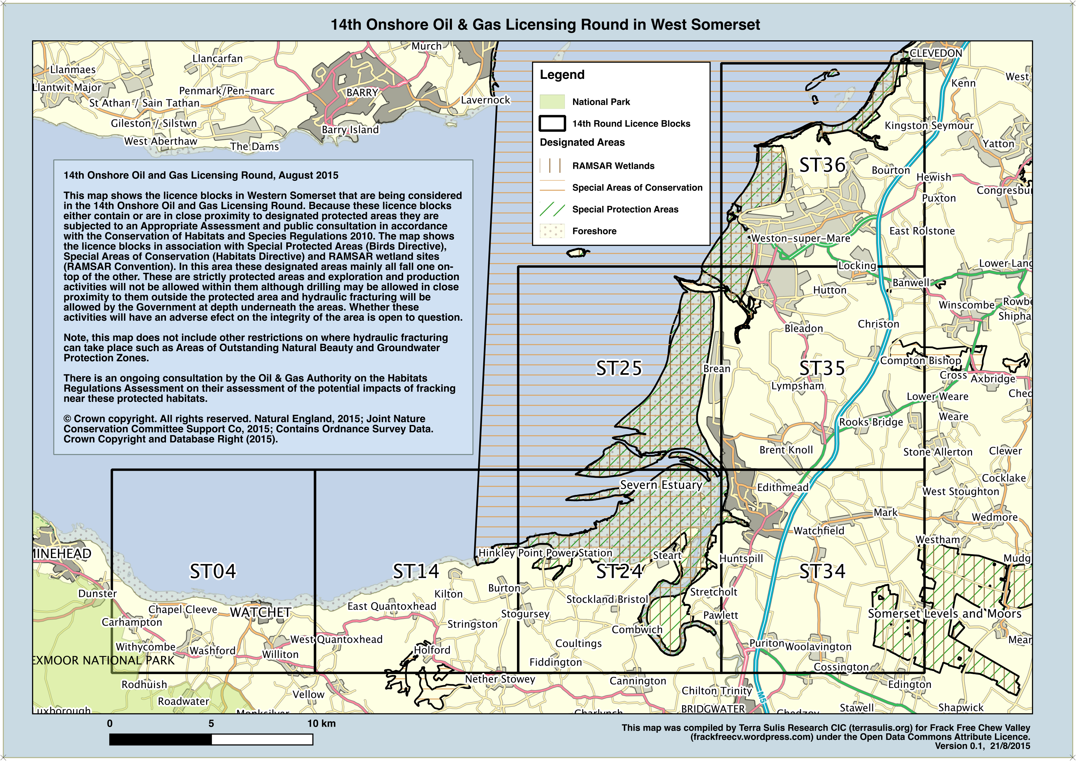
Sir Humph: “Thirteen blocks located to the west and east of Somerset are being considered as part of the 14th licensing round, subject to the Habitats Regulations Assessment consultation. A map of licences being considered in the 14th licensing round can be found here.

Ah, right. Thirteen blocks in west and east Somerset are being considered as part of the 14th Licensing Round even though they are also not in the BGS shale gas prospective area either. Err, so they must be being licensed for something else other than shale gas, something like CBM and Shale (Oil) – as stated in Sir Hump’s list of licences.  So, not being in the BGS shale gas prospective zone is a good thing in Bath, but not in any way relevant in Weston, Frome or the Forest of Dean – based on the same criteria of not being in the BGS shale gas prospective zone (Ed. Has Sir Humph got that right, it sounds like nonsense?).

Sir Humph’s Department has actually licensed 1,200 square kilometres in the Forest of Dean (CBM), Wiltshire (CBM) and the Somerset coast (Shale but not Shale Gas) that is not in the BGS Shale Gas prospective area. So the talk about not being in the BGS shale gas prospective area and the careful use of the words ‘reserve’ and ‘resource’ is just a meaningless ruse that only Sir Humph could articulate to make everything sound OK?

Sir Humph also forgot to mention that the Habitats Regulations Assessment consultation had three possible outcomes all of which resulted in the licenses being issued, no matter how sensitive the area or the consultation response.

Sir Humph: “PEDLs do not give permission for specific operations, such as drilling. Rather, they grant exclusivity to licensees, in relation to hydrocarbon exploration and extraction (including for shale gas but also for other forms), within a defined area. Any licensee looking to explore for hydrocarbons would have to apply for planning permission and various permits in advance of any drilling.

Sir Humph is fixated on only articulating “Shale Gas” at the exclusion of the “other forms” such as CBM and even Underground Coal Gasification. Why would Sir Humph not want to say CBM or “Underground Coal Gasification”?

Sir Humph: “I am grateful for the opportunity to discuss this matter with you and with James Heappey MP recently, and hope that this brings assurance that there are no known shale reserves in your area and currently no plans to explore for any.

Phew, so now we know that there are no shale ‘reserves’ in the area (the ones that haven’t been calculated, so how could there be any?). But what about the CBM ‘resources’ – the ones that have been calculated and the ones that UK Methane recently said in their relinquishment report (filed in Sir Humph’s office) were “probably prospective” and which any company can apply for an exploration licence for the next time around.

Sir Humph: “I regret that this situation has in the past been unclear to some of your constituents, and I hope you can take the necessary steps to alleviate their concerns.

Glad that Sir Humph has cleared up that confusing mess by providing a carefully worded explanation of what isn’t significant in this area. Pity he didn’t mention anything that was of primary interest even if it isn’t covered by recent reassuring legislation.

Bernard: “But surely the citizens of a democracy have a right to know“.

Sir Humph: “No. They have a right to be ignorant. Knowledge only means complicity in guilt; ignorance has a certain dignity“.

James Hansen’s view on UK’s dash for fracked gas

Dr James Hansen, former head of NASA’s Goddard Institute for Space Studies and one of the world’s most prominent climate scientists, has just said of UK’s dash for fracked gas – “Well, that’s screwing your children and grandchildren. Because if you do that, then there’s no way to avoid the consequences [of] multi-metre sea-level rise But we can’t do that and that’s what the science says crystal clear. And yet politicians pretend not to hear it, or not to understand it” [hear it all here].  This is rather relevant to Somerset seeing as the whole coast from Clevedon to Minehead is both being licensed for fracking and much of it is close to or below the current high tide level, which is considerably higher in the Severn Estuary than other coastal areas around the UK thanks to its geography.

Legally protected wildlife habitat in the Estuary is already being squeezed between rising sea level and the hard sea defences that snake around the coast, with new habitat having to be created through managed retreat at the cost of tens of millions of pounds – Steart Marsh. The Department for Energy and Climate Change is also having to ensure that sea defences at Hinkley Point are bolstered to prevent them being undermined by the rising tide.

A grotesque tautology is now in play whereby the sea level is already rising and protected wildlife habitat is being lost, having to be replaced at great cost, at the same time the area is being licensed for fracking that will result in more cumulative greenhouse gas emissions, leading to more sea level rise and more habitat loss and expense – all within plain sight of a nuclear power station and the site of the Swansea Bay tidal lagoon. You really couldn’t make it up. Nor could you make up the job description of the Secretary of State for Energy and Climate Change who (thanks to the Infrastructure Act) is now simultaneously responsible for both reducing carbon emissions and maximising the use of domestic fossil fuels without carbon capture and storage, i.e. maximising them.

Mr Jacob Rees-Mogg, MP for the Chew Valley and climate sceptic, has said that it is a choice between “cheap energy” and “living in the stone-age” – a false dichotomy that ignores environmental costs and fossil fuel subsidies. He says that we should only adapt to climate change (I thought he denied it? Ed.) rather than mitigate further change by reducing emissions, suggesting that we take a leaf out the the Dutch book by building the sea defences higher and higher – as the Dutch “have done for hundreds of years”.  He selectively forgets that historically the Dutch drained their land using windmills, an option not available in England as Mr Rees-Mogg has played his part in ending onshore wind – the least costly renewable energy. Another conundrum for the Secretary of State – how to deliver carbon reduction targets at least cost whilst at the same time closing down the least cost renewable option? – onshore wind.

So, as a politician does Mr Rees-Mogg pretend not to hear what science is saying about the climate (“the quasi religious Green movement” with its “environmentalist obsession”), or does he simply just not understand it? Perhaps he is listening too much to Christopher Booker’s climate myths  rather than spending any time engaging with science and people like James Hanson, who not only understands the science but who also advocates a market solution – another thing (surprisingly) Rees-Mogg doesn’t bother with unless massive fossil fuel subsidies are included. Ask a NASA scientist – or any of the 97% of climate scientists who have published and expressed a position on global warming.

Respond to the Habitats Regulations Assessment

The Department for Energy and Climate Change is currently undertaking a consultation on the Habitats Regulations Assessment (HRA).  The HRA is a legal requirement to ensure that protected habitats will not be impacted by adverse effects on their integrity by shale gas operations, including fracking. In Somerset this mainly means impacts on the protected areas between Clevedon and Minehead and parts of the Somerset Levels. These protected areas are wetlands and are protected by the international convention, UK and EU law – the Ramsar Convention, Habitats Conservation Regulations 2010 and the European Habitats and Birds Directives.  The areas are protected because they are internationally recognised as important sites for biodiversity.

Somerset 14th Round Protected Areas, West

Somerset 14th Round Protected Areas, West

Recent changes to the law mean that fracking can take place underneath all of these areas but the HRA accepts that fracking operations would have a negative impact if they were to take place on the surface inside the protected areas. This is stating the obvious as these are strictly protected areas. After hundreds of pages of inpenetrable maps and analysis the HRA concludes that surface operations could take place anywhere outside of the protected areas without adverse impacts, subject to a few non-biding licence advice notices.  The HRA provides no option not to issue a licence no matter what the environmental conditions.

The government has been advised by their former Chief Scientific Advisor that exploitation of shale gas would lead to additional cumulative greenhouse gas emissions and further global warming unless displaced fuel is not burned. The government can’t stop Qatar selling their gas to others if we don’t buy it. Global warming causes sea level rise and sea level rise is expected to remove three quarters of the intertidal habitat in the Severn Estuary over the next 60 years. Exploiting shale gas will therefore have a very plausible detrimental impact on these protected coastal habitats which the government has a legal obligation to protect. The HRA doesn’t even mention climate change or sea level rise, despite DECC being concerned about sea level rise and flooding in relation to Hinkley Point power station – which is slap bang in the middle of the Somerset assessment area. The HRA also relegates surface contamination from leaks & spillage and potential well failure to a stage of fracking operations that they say is not relevant to the assessment. It clearly is.

The assessment closes at 11:45 am on the 29th September. You can respond to the assessment and make your voice heard.

The HRA documents are voluminous and difficult to understand. You can see Frack Free Chew Valley’s response in summary and in detail by following these links.

HRA Summary

FFCV Response to the Habitats Regulations Assessment

NB The government is filtering the best scientific advice from its Advisors and Parliamentary Environmental Audit Committee through the prism of a self appointed industry funded  ‘task force’ and is cherry picking evidence to justify pressing ahead with shale gas no matter what. The issues of climate change and sea level rise are just massive to the future of Somerset and its effects are already being felt. The HRA ignores this and the well known critical drainage situation both on the coast and inland.

14th Onshore Licensing Round

The government has announced the preliminary results of the 14th Onshore Licensing Round for oil and gas licenses.  There are two categories  i) 27 blocks that will be offered licences without further assessment and ii) a further 132 blocks that first need to undergo Appropriate Assessment and consultation.

A block is an Ordnance Survey 10 x 10 km grid square. In Somerset all of the 10km blocks are in the ‘ST’ 100km block. The licenses don’t extend into the sea but they do extend onto the large foreshore areas, some of which are protected.

The ‘Appropriate Assessment’ refers to an assessment of the licence blocks in relation to the Conservation of Habitats and Species Regulations 2010.

In Somerset the previous licences in the Bristol-Somerset coalfield have not been renewed, so those areas including the Chew Valley are not at risk of unconventional gas exploration and development in this licensing round. It is a good thing too because the Department of Energy and Climate Change has confirmed to us that the ‘safeguards’ in the Infrastructure Act (such as not fracking in Areas of Outstanding Natural Beauty and not fracking at shallow depths) do not apply to coalbed methane.

Eleven of the licence blocks in the Appropriate Assessment category are either within Somerset or adjacent to Somerset and include 400 km2 to the east of Frome and a large area along the cost from Clevedon to Dunster. These licence blocks must go to consultation because they either contain or are in close proximity to designated protected areas protected by law and international treaty.  DECC’s consultants have advised that with respect to the Habitats Regulations ALL of these blocks (with some caveats) can be licensed and that gas development will not have ‘Adverse Effects on Integrity’. This basically means that drilling for gas can be conducted up to the boundary of the designated areas and beneath the designated areas. The Government has a track record in ignoring the results of consultations.

This is the area and licence blocks in West Somerset with the Special Areas of Conservation, Special Protection Areas and RAMSAR wetland sites indicated. Click to download.

14th Round Onshore Oil & Gas Licensing Round, West Somerset

14th Round Onshore Oil & Gas Licensing Round, West Somerset

This is the area and licence blocks to the East of Somerset:

14th Round Onshore Oil & Gas Licensing Round, East Somerset

14th Round Onshore Oil & Gas Licensing Round, East Somerset


You can respond to the Government Consultation on the Habitats Regulations Assessment via the DECC web site – or here is the document you need to refer to: Consultation_OGA_branded_summary_document.

Here is a reduced size collated version of DECC’s Appendix D and maps – Block_ST_14th_Round_reduced_size.

NB These maps only contain information regarding the Habitats Regulations which are directly relevant to the consultation. That is not the whole story however and other maps will follow with AONBs, National Parks, and SSSI”s (now removed from the ‘safeguards’) etc.


This web page contains map information that is copyright 2015 Ordnance Survey and the Joint Nature Conservation Committee under the Open Government Licence.

See JNCC for information on the designated sites protection status.

Do legal safeguards relating to fracking for Shale Gas apply to Coalbed Methane in Somerset?

Safeguard: A measure taken to protect someone or something or to prevent something undesirable

The Infrastructure Act 2015 contains a list of twelve onshore hydraulic fracturing safeguards.

The list of safeguards is quite long (see below) and includes a condition that “prohibits associated hydraulic fracturing from taking place in land at a depth of less than 1000 metres”, a condition prohibiting “associated hydraulic fracturing” from taking place in groundwater protection source areas and other protected areas such as Areas of Outstanding Natural Beauty  and a condition ensuring that methane in ground water will be monitored for 12 months prior to commencing “associated hydraulic fracturing”.

The Department for Energy and Climate Change (DECC) has confirmed to FFCV that the definition of “associated hydraulic fracturing” in the Petroleum Act 1998 and the Infrastructure Act 2015 DOES NOT APPLY to Coalbed Methane (CBM).  It follows therefore than none of the legal safeguards in the Act apply to CBM either.

The government’s definition of associated hydraulic fracturing “means hydraulic fracturing of shale or strata encased in shale” and does not include coal where coalbed methane is found.  On this issue DECC have said “To confirm, this definition does not apply to CBM“.  CBM is the primary unconventional gas of interest in the Bristol-Somerset coalfield.

MP for North East Somerset, Mr Jacob Rees-Mogg, voted for the Infrastructure Act and has said in letters to concerned constituents:

J R-M: “The Government has proposed to allow developers to access the ground up to 5000 feet below private land without the risk of breaching trespassing laws

This is an obtuse way of saying that fracking will not occur in the top 5000 feet depth from the surface (although this is not actually correct as the Act says 1000m which is 3280 feet).  According to DECC this does not apply to CBM in Somerset. The Government’s Planning Portal states that CBM extraction “is likely to be achievable between 200 and 1500 metres”. There would appear to be no legal safeguard prohibiting fracturing of coal for CBM at depths as shallow as 200m either outside or inside the Mendip Area of Outstanding Natural Beauty.

J R-M: “The Government made a number of alterations to the Bill such as declaring an outright ban on fracking in National Parks and, of particular relevance to North East Somerset, Areas of Outstanding Natural Beauty

According to DECC this does not apply to CBM in Somerset. This is because the protection is contingent on the definition of associated hydraulic fracturing not the definition of protected areas such as AONBs.

J R-M: “The length of time during which companies must monitor the environment at a fracking site before work commences has also increased from a voluntary three-month period to a mandatory twelve month period

According to DECC the condition to monitor methane in groundwater for 12 months before fracturing does not apply to CBM in Somerset. This is because the protection is contingent on the definition of associated hydraulic fracturing which doesn’t apply to CBM.

J R-M: “There is a provision for compensation payments to affected communities”

According to DECC this won’t apply to CBM as the Act only applies to shale gas. Any payment would therefore be voluntary under the industry’s code.

J R-M: “I voted for the Bill as I am confident that the risks are tolerable

In relation to coalbed methane in Somerset Mr Rees-Mogg does not appear to know what law and safeguards apply or do not apply, so how can he assess the risks of coalbed methane production in his constituency?

According to the Somerset Guardian Mr Rees-Mogg has urged local residents to ignore ‘scare stories and scaremongering‘ around fracking and has ‘dismissed the concerns voiced by opponents‘. He has also said that “lack of information about the locations, size and scale of exploration works was in part to blame for the anxiety” whereas the location, size and scale of exploration work is well known because the American Coalbed Methane industry has described it in some detail – see the GeoMet report – and is the cause of much anxiety!

Resources

Feeling anxious?

Fracking safeguards that don’t apply to Coalbed Methane in the Bristol-Somerset coalfield?

The Infrastructure Act 2015 and changes to the Petroleum Act 1998 have a number of onshore hydraulic fracturing “safeguards” which only apply to Shale Gas, including:

(a) a condition which prohibits associated hydraulic fracturing from taking place in land at a depth of less than 1000 metres;

In addition to this are a set of conditions, including:

  1. The environmental impact of the development which includes the relevant well has been taken into account by the local planning authority
  2. Appropriate arrangements have been made for the independent inspection of the integrity of the relevant well
  3. The level of methane in groundwater has, or will have, been monitored in the period of 12 months before the associated hydraulic fracturing begins
  4. Appropriate arrangements have been made for the monitoring of emissions of methane into the air
  5. The associated hydraulic fracturing will not take place within protected groundwater source areas
  6. The associated hydraulic fracturing will not take place within other protected areas
  7. In considering an application for the relevant planning permission, the local planning authority has (where material) taken into account the cumulative effects of— (a) that application, and (b) other applications relating to exploitation of onshore petroleum obtainable by hydraulic fracturing
  8. The substances used, or expected to be used, in associated hydraulic fracturing— (a) are approved, or (b) are subject to approval, by the relevant environmental regulator
  9. In considering an application for the relevant planning permission, the local planning authority has considered whether to impose a restoration condition in relation to that development
  10. The relevant undertaker has been consulted before grant of the relevant planning permission
  11. The public was given notice of the application for the relevant planning permission

Plus two further conditions:

(a) that appropriate arrangements have been made for the publication of the results of the monitoring referred to in condition 4 in the table [above];

(b) that a scheme is in place to provide financial or other benefit for the local area.

What is “associated hydraulic fracturing”?

The Acts define “associated hydraulic fracturing as:

Associated hydraulic fracturing” means hydraulic fracturing of shale or strata encased in shale which —

(a) is carried out in connection with the use of the relevant well to search or bore for or get petroleum, and

(b) involves, or is expected to involve, the injection of—

(i) more than 1,000 cubic metres of fluid at each stage, or expected stage, of the hydraulic fracturing, or

(ii) more than 10,000 cubic metres of fluid in total.

NB DECC have confirmed that this definition DOES NOT APPLY to Coalbed Methane.

PEDL 227 – “in process of being relinquished”

According to the Oil & Gas Authority Petroleum Exploration and Development Licence (PEDL) 227 which is held jointly by UK Methane and Eden Energy is in the process of being relinquished, see https://www.facebook.com/FrackfreeSomerval. This is the last remaining PEDL in Somerset and with its relinquishment Somerset will be Frack Free! Unless that is other gas exploration companies have applied for Somerset licences in the 14th Onshore Licensing Round, the results of which have been delayed until after the election.

Considering that over the last 20 years the Somerset coalfield has been evaluated for unconventional gas twice (by GeoMet Inc and by UK Methane/Eden Energy) and twice the licenses have been relinquished without any drilling taking place this area should now be excluded from further petroleum exploration licensing.

Australian Eden Energy and UK Methane have for some years been trying to consolidate their shared PEDLs into a merged company but without success. The terms of the deal were that Eden would be entitled to receive “£1.14 million together with a 33.33% shareholding in the merged company“. Eden reported on 30th April 2015 that “it is now highly unlikely that this merger will proceed on the terms previously announced“.  Eden Energy and UK Methane relinquished their other Somerset exploration licenses last summer “due to both environmental and social reasons“. Whilst Eden Energy is still listing PEDL 227 in their Interests in Tenements it looks like “environmental and social reasons” mean that it won’t appear in their next quarterly report.

This is a watershed moment in which by shedding its petroleum exploration licenses Somerset can transition from the fossil fuel age into a renewables future by leaving its fossil carbon in the ground, thereby playing its part in averting dangerous climate change.  Climate change is a scientific reality not a matter of political opinion and in election week our politicians need to grasp this opportunity to make sure that Somerset’s fossil carbon stays in the ground and isn’t licensed out to the next highest bidder.


14th Onshore Licensing Round – Relinquished PEDLs back in the pot

Today (28th July 2014) the Department for Energy and Climate Change has launched the 14th onshore licensing round for unconventional oil and gas with the headlines saying that fracking will not be allowed in national parks or Areas of Outstanding Natural Beauty other than in exceptional circumstances – to be decided by the Minister for Communities.

The National picture is shown here, click to enlarge:

14th Licensing Round, England, Scotland, Wales. Green = national parks, Cyan = AONB, Red = current licenses, Pink = new areas being offered for licence. Copyright 2014, DECC, Ordnance Survey.

14th Licensing Round, England, Scotland, Wales. Green = national parks, Cyan = AONB, Red = current licenses, Pink = new areas being offered for licence. Copyright 2014, DECC, Ordnance Survey.

The situation in the Chew Valley and Somerset is that the previously relinquished areas are back in the pot:

14th Licensing Round, England, Scotland, Wales. Green = national parks, Cyan = AONB, Red = current licenses, Pink = new areas being offered for licence. Copyright 2014, DECC, Ordnance Survey.

14th Licensing Round, England, Scotland, Wales. Green = national parks, Cyan = AONB, Red = current licenses, Pink = new areas being offered for licence. Copyright 2014, DECC, Ordnance Survey.

What does this mean for the Chew Valley and surrounding area?

  • Parts of the valley may be protected by the AONB
  • Parts of the valley should be protected through the water source protection zones but this is patchy
  • PEDL 227 around Ston Easton remains. This area is neither within the AONB or water source protection zones. UK Methane’s licence contains a firm commitment to “obtain 19km of 2D seismic data on Block ST65” (the upper portion), “obtain 1.5km of 2D seismic data on Block ST64”, “drill one well to a depth of 800m”.
  • Parts of the Chew Valley are neither within the AONB or the water source protection zones which only cover ground water aquifers. Having been both evaluated and relinquished at least twice these areas are again been offered to gas companies for exploration in the full knowledge of previous evaluations.

The new Energy Minister Matthew Hancock adds:

“As one of the cleanest fossil fuels, shale gas can be a key part of the UK’s answer to climate change and a bridge to a much greener future.”

Rather than “one of the cleanest fossil fuels” the Minister presumably means “one of the least dirty”. His view of unconventional gas as a bridging fuel is not shared by DECC’s outgoing Chief Scientific Advisor, Professor David MacKay of Cambridge University, who recently advised DECC that in the absence of a globally binding agreement to control carbon dioxide emissions that any new fossil fuel would lead to increased cumulative greenhouse gas emissions leading to further global warming. Ministers have collective amnesia when it comes to this inconvenient truth.

MacKay and Stone, DECC 2013, said:

“The view of the authors is that without global climate policies (of the sort already advocated by the UK) new fossil fuel exploitation is likely to lead to an increase in cumulative carbon emissions and the risk of climate change. We would strongly encourage continued efforts from the UK and internationally to address this issue, proportionate to the emissions involved.”

In response to Cuadrilla’s position FFCV says: Why Cuadrilla is Wrong About Shale Gas Carbon Emissions

On the same subject Professor Kenvin Anderson of the Tyndall Centre for Climate Change Research says:


The Bad News and a Glimmer of Hope

NEWS ALERT!

The bad news is that FFCV has located a Department of Energy and Climate Change (DECC) report from 2000 prepared by American coalbed methane (CBM) specialists GeoMet Inc which lays bare what the government already knows about coalbed methane exploration in the Chew Valley and surroundings – the extent of the prospective area, the estimated volume of the gas and the number of wells needed to extract it. In the 400 sq km around the Chew Valley lake 108 sq km are considered prospective and if fully developed would require about 300 gas wells on a 566m well spacing. It is quite shocking that this public information has not been made available to local communities (or to BANES) so that they can make informed decisions about unconventional gas and how it might affect them, their families and their businesses. What is more this report was not referred to in the report on unconventional gas prepared for BANES by the British Geological Survey – even though they make reference to it in their national CBM evaluation. Read our web page on the subject and the report and maps we have prepared from the original government report and digital map data.

FFCV CBM Report

FFCV CBM Report

The glimmer of hope is that BANES has been informed by DECC that three of the four current Petroleum Exploration and Development (PEDL) licences covering Somerset have been relinquished (i.e. given back to the State) by the gas companies (PEDLs 225, 226, 228), including most of the Chew Valley catchment. However these PEDLs could be put back into the pot and offered again to other gas companies for exploration and development as part of the 14th Onshore Licensing Round, which is imminent. On the basis that these areas have now twice been evaluated by gas companies and twice they have decided not to develop them it is imperative that they are now excluded from further licencing rounds to protect them. Help make this happen by writing to BANES, to your MP and most importantly to Rt Hon Michael Fallon (correspondence@decc.gsi.gov.uk) the minister of state responsible for onshore unconventional gas. That the government should knowingly licence these sensitive areas exposes the extent to which the administration is willing to gamble with what David Cameron only recently described as one of “Britain’s greatest assets” – the beautiful countryside of the West Country – not to mention your well being.

Further bad news though is that licence PEDL 227 has been extended indicating that the company UK Methane is probably planning to apply for planning permission to drill an exploration bore hole. The DECC/GeoMet report indicates where within that PEDL the exploration might take place and if productive how may wells might be needed to extract it – its about 85.

Somerset PEDL Map

Somerset PEDL Map (Source Frack Free Somerset)

Let your MP know what you think and make sure they know what the government actually knows about unconventional gas in their constituencies rather than listen to their parroting and cheer-leading of the coalition government’s position.